

Far North Queensland Water Security Project – Summary of proposal
Download an A4 PDF of the proposal here
The Far North Queensland Water Security Project proposal to build three dams that can connect to Tinaroo Dam. This will solve multiple problems re-occurring over the Atherton Tablelands in Far North Queensland.
The problems
- Agriculture needs 80,000ML per annum. Agricultural sector is demanding another 80,000 megalitres per annum to increase productivity.
- Cairns City needs 50,000ML per annum. Cairns City is demanding 50,000 megalitres increase in use by 2050 and are looking to Tinaroo Dam.
- Tourism needs Tinaroo Dam to be above 60% capacity. The tourist industry is asking that Tinaroo Dam not be drawn down below 60% as it detracts tourists and consequently a loss to the retail industry across the Tablelands.
- Tinaroo Dam is not big enough for these future demands.
The solution
- Three new dams on the Beatrice River, Dirran Creek and North Johnstone River.
- 97% expectation of 176,000 megalitres annually, minimum yield of 141,000 megalitres (historial no-fail yield), (Jacobs Australia PL).
- Water can be pumped/siphoned to Tinaroo to retain capacity at a minimum of 70%. These dams are about 30 metres above Tinaroo.
- Excess water can be used for substantial hydro-electricity production.
What’s needed
- Funding to get an engineering preliminary report on this project proposal.
- To get the proposal to the top of the government developments for Queensland’s future sustainability.

Introduction
Far North Queensland Water Security Project
The FNQ Water Security Project will provide a long-term solution to current domestic water supply and irrigation water supply problems for the Tablelands, Mareeba-Dimbulah area and Cairns City well into the future.
This project is proposed in response to agricultural demands for expansion and security of water.
This project will resupply Tinaroo Dam with an expected average of 176,000 megalitres (ML) per year (with a minimum of 141,000 ML historial no-fail yield) of potable water from three dams on the Beatrice River, Dirran Creek and headwaters of the North Johnstone River.
Future water requirements
The agricultural sector of the Mareeba-Dimbulah irrigation area has requested a 77,000 ML increase in water allocation equating to an 8000-10,000 hectare expansion of agriculture. Much of this land is already cleared, but cannot proceed without reliable irrigation source.
Cairns City has expressed need for an increase of 50,000 ML by 2050.
Cairns City has been relying on Behana Creek gravity feed and the 44 km2 catchment of Lake Morris and this is now too small for future growth and security. Cairns City has expressed a strong interest in taking water from Tinaroo Dam.
Tinaroo Dam capacity
Tinaroo Dam, the main storage for the Mareeba – Dimbulah Irrigation Area, was built for the tobacco industry which was restricted in size by quotas to each grower. The 1980s and 1990s saw a radical change in the Government closing down tobacco growing.
Farmers, to their credit, diversified into other crops to survive. Many of these crops originate from rainforest lands around the world such as bananas, mangoes, lychees, sugarcane and avocados.
These crops require water all year round, meaning the use of more water than the original crop – tobacco. Without water these crops will fail. With water these crops are of high economic value both domestically and for export.
Since Tinaroo Dam was built it has also become a popular tourist destination and consequently an important economic base for businesses in the Cairns Hinterlands. However, when Tinaroo Dam falls below 60% capacity, Marine Safety Queensland closes the dam to boating for safety and tourism is restricted.
Project detail
The Project is outside the towns of Millaa Millaa and Malanda, is easily accessible for construction and maintenance, and is located within freehold lands on very marginal prospects, mainly in steep valleys.
Why this Project?
This is a resupply project to Tinaroo Dam supplying an established industry worth 100’s of millions of dollars to Australia each year.
Cairns is a very important city in Australia and because of its surrounding natural assets will continue to be a major tourist destination and deserves water security.
The water being offered is clean, cold potable water which is very rare in Australia.
There is the additional possibility for hydro-electricity to be produced using excess stream flow – base stream flow for project has the potential of 380,000 megalitres annually (estimated 176,000 megalitres required to keep Tinaroo Dam at 70% minimum throughout the year under normal circumstances).
This hydro-electricity potential would be a valuable economic green energy offset to the construction and maintenance cost and hopefully offset the cost of water delivery to Tinaroo Dam.
Proposal
Tinaroo Dam has a catchment area of 545km2. At regular intervals Tinaroo is low in its capacity which affects farmers, tourism, hydro-electricity production which finally affects the economy of the whole community.
Cairns is asking for a solution to their long- term water supplies and are looking towards the Tablelands for an answer.
Nullinga Dam has been muted as a solution but it fails because it does not have a constant and reliable water supply. The only permanent water comes from the back of Baldy Mountain Forest in the form of three small creeks draining about 25km2. The total catchment for Nullinga is about 325km2 but most of this catchment only receives storm rains and does not receive the monsoonal rains that fall east of the Great Dividing Range. Compare that to Lake Morris that drains from 44km2.
Even though Nullinga is proposed to be bigger than Tinaroo it will prove to be another Ross River Dam – shallow, drained of water quickly, high evaporation rate and in many years never filled and not fulfilling its promise of water for the Mareeba Dimbulah Water Supply Scheme (MDWSS) and again this shortfall will put pressure back on Cairns.
Our proposal
To supply water to MDWSS and Cairns for 100+ years from the North Johnstone River Catchment to allow growth to the agricultural sector and not increase the cost of water by allowing a greater increase in the throughput of water in Tinaroo Dam. The idea is not to build another large dam but fill an existing dam with available water. The cost of transferring this water will be offset by hydro electricity generation.
The catchment would be diverted by three dams on the Beatrice River, Dirran Creek and North Johnstone River.
These rivers lie east of Malanda – Millaa Millaa which receives 2000+mm annually.
Preliminary yield assessment
Jacobs Australia Pty Limited conducted a preliminary yield assessment of this idea, organised by the Far North Queensland Regional Organisation of Councils. The report supported the numbers listed in this document.
Reasoning behind three dams
- Three dams guarantee water security.
- Approximately 380,000ML will pass through these dams each year (to be substantiated by hydrologist).
- They can work in concert to guarantee water supply if any one dam requires maintenance.
- Taking water from each in concert guarantees downstream environmental flows.
- This will reduce the likelihood of environmental stress on any of the watercourses that may be caused by concentrating all demands on one watercourse.
- Three dams will provide a substantial hydro-electric component and therefore substantial employment in the future.
- The concept of hydro-electricity in this instance would be to reduce the cost of delivery to Tinaroo to zero. Irrigation water cannot be charged out at a price expected to pay for the whole development costs. Farming becomes uncompetitive on the international market place and makes farming in Australia economically unviable. (Potential hydro-electric production can only be calculated after hydrologist reports on available water and dam capacities).
- Southern Tablelands may benefit from the employment boost simply by utilising land that is unproductive due to the steep terrain.
- Three dams will provide about 90,000 ML immediate backup to Tinaroo which will become more relevant to Cairns and Mareeba in drought years (to be substantiated by hydrologist).
- Tinaroo was built to supply water to a tobacco industry which grew a crop annually.
- Since tobaccos demise farmers have turned to crops originating from rainforest species such as bananas, avocadoes, lychee and mangoes or the tropical grass sugarcane.
- All these crops require water all year round, not just a growing season, and therefore require more water from Tinaroo than had originally been foreseen.
- Several of these crops are high value to farmers and keen interest in expanding production has been noted but is not possible without substantial water increase. (77,000 ML Build Qld).
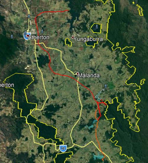
Proposed dam locations and catchment
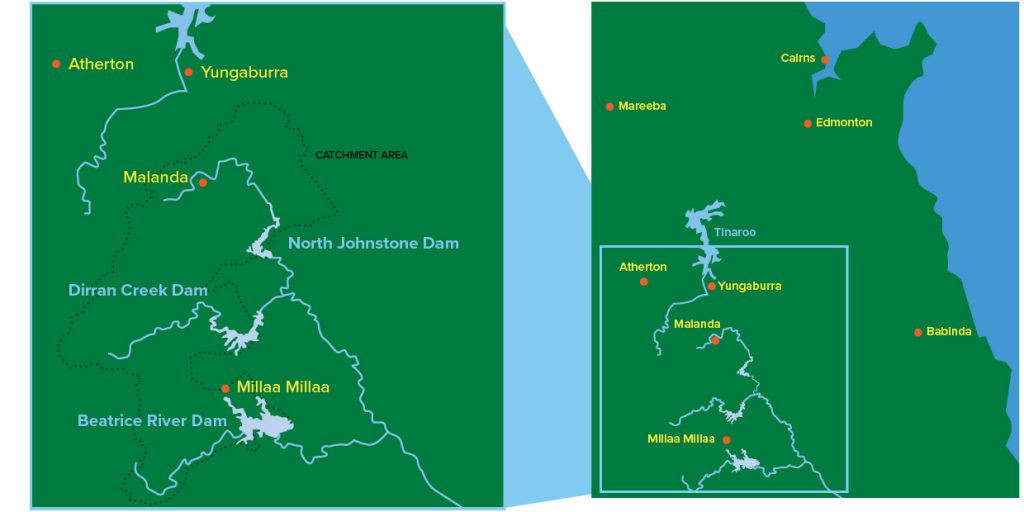

Map showing catchment areas and dam locations.
Sourced from the FNQROC Yield Assessments report by Jacobs Australia Pty Ltd.
Dam 1: North and South Beatrice Rivers
Proposed Beatrice River Dam expected to yield 89,000ML at base flow calculations.
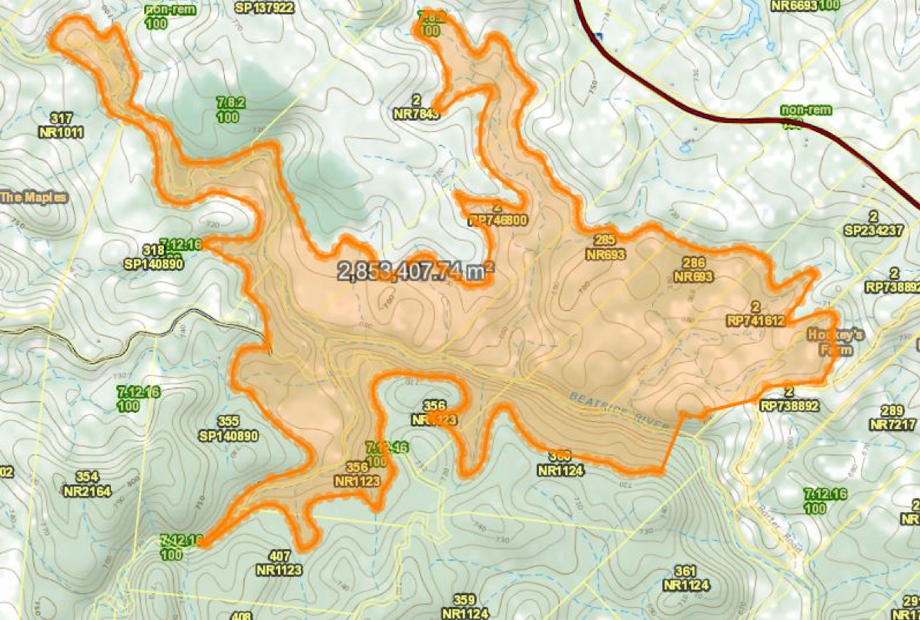
Dam 1: North and South Beatrice Rivers. Orange indicates catchment area of dam.
This site has a catchment area of 85km2. Located on both the North and South Beatrice Rivers about 5kms south-east of Millaa Millaa (at -17.542988, 145.649326).
Full supply level calculated at the 700m level contour would create a reservoir of 284ha. A comparison is Lake Morris at 332ha.
The dam wall is about 300m across the Beatrice River, 30m high. It is estimated there would be 450ML available to be pumped immediately.
The strategic location of this dam is to maximise inflow, minimise environmental impact and be deep enough to maximise pumping efficiency. Hydro electricity is envisaged at this dam when water is not required for Tinaroo Dam.
This water would be pumped 10km to Dam 2 Dirran Creek.
Impacts:
- One home (resort) would be inundated at the end of Mullins Road, Lot 315 SP140890.
- Several properties may become unviable for cattle grazing due to loss of area.
- No road infrastructure would be affected.
- Mostly regrowth rainforest will be inundated mainly on the south side of the Beatrice.
Dam 2: Dirran Creek
Proposed Dirran Creek Dam expected to yield 95,000ML at base flow.
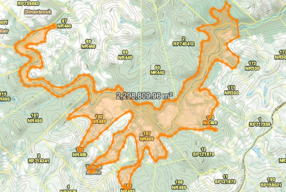
Dam 2: Dirran Creek. Orange indicates catchment area of dam
This site has a catchment size of 90km2 at the proposed dam site. Located on Dirran Creek about 6km north north-east of Millaa Millaa (-17.45915, 145.63473).
With a wall 250m long at the 700m level contour will compound about 229ha and is estimated to have 8,000ML available for immediate pumping.
As with Dam 1, it is located for depth to maximise water harvesting and hydro electricity when not required for water supply. A 5.3km pipe will connect to the pipe at Dam 3 North Johnstone River.
Impacts:
- Two dwellings would be inundated on Lot 90 NR440 and Lot 167 NR499.
- Rainforest will be inundated on the steep slopes into the Dirran Valley mainly on the northern side.
Dam 3: North Johnstone River
Proposed North Johnstone River Dam expected to yield 200,000 ML/year at base flow.
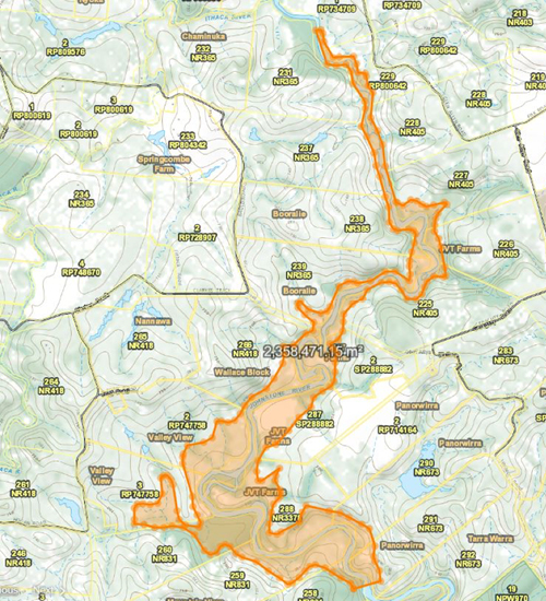
Dam 3: North Johnstone River. Orange indicates catchment area of dam.
This site has a catchment size of 190 km2 at the proposed dam site. Located 5.4 km south of the North Johnstone Bridge on Glen Allyn Road (-17.41230, 145.65065).
With a 270 metre long wall, 23 metres high the dam is estimated to compound about 235 ha at the 680 metre contour.
The elevation of this dam was reduced to eliminate impacts on Glen Allyn Road and the North Johnstone Bridge. This dam is expected to yield a minimum 200,000 ML / year at base flow. Hydro electricity will be produced when water is not required for Tinaroo.
Impacts:
- No houses will be affected by this inundation.
- About 33 ha of regional ecosystem (RE 7.8.2) remnant rainforest will be inundated.
- About 10ha of tea plantations will be inundated.
Potential hydro-electricity production
As stated, there will be three dams built on the headwaters of the North Johnstone River.
It is envisaged that each dam will have an electricity generator in proximity to the dams utilising all waters not required to flow to Tinaroo Dam. This should equate to a minimum of 180,000 ML that may be used for electricity through these three dams.
Another generator may be envisaged where the water enters Tinaroo Dam with about 150,000–200,000 ML being transferred during the year.
Sunwater has a generator on the feeder channel for the Mareeba – Dimbulah Irrigation Scheme and its production will increase with an extra 80,000 ML for increased agriculture production.
The potential for another generator on the environmental release flows off the existing valve at Tinaroo Dam wall given Cairns City needs another 50,000 ML.
50,000 ML increased environmental flows means the potential increase in power generation at the Barron Falls Hydro Station below Kuranda
Conclusion
The potential for five new Hydro generators and an increase in production to the two existing generators bodes well for clean green renewable energy being a Federal Government policy goals for the future.
See link below
Concept of Pipeline from Dams to Tinaroo
Hydro example Wivenhoe

Environmental concerns
There will be people who knowing that the Far North Queensland Water Security Project lies within the Wet Tropics bioregion will be concerned that damage to the environment will be too great a sacrifice to be allowed to continue.
This article is to assure you that the greatest environmental sacrifice happened 80-100 years ago with the total denudation of rainforest from these freehold lands.
The rainforest was cleared right to the water edge along all the creeks and rivers across the Atherton Tablelands and the areas of freehold within the project were no exception.
Sporadic clearing of remnant rainforest continued until the 1980’s. The impact of this clearing was never scientifically recorded but it must have been horrific.
This project is totally based within these impacted freehold lands and given that water will be given depth through dams, no cessation of water flow is envisaged which at this stage could be the only environmental concern.
It has been calculated (to be confirmed by Hydrologist) that 380,000ML minimum will pass through these dams annually, of which 150,000-200,000ML will be used for the Mareeba Irrigation and Cairns Water Supply. Therefore at least 180,000ML will flow past the dams, hopefully through
hydro-electricity, along the same course of millions of years.
Between and below these dams are major watercourses that could not be captured by this project.
Some of these include: Theresa Creek, Ellinjaa Creek, Gilles Creek, Five Mile Creek, Henrietta Creek, Douglas Creek, Bradman Creek, Learmouth Creek, Miyee Creek, Little Beatrice River, Coolamon Creek, Badgery Creek and hundreds of minor unnamed permanently running creeks.
Creatures and fish that use these waterways would have minimum impact.
That is platypus, eels and turtles are well known to traverse short distances to avoid obstacles on water courses and therefore will pass around a dam wall.
Sooty Grunter inhabit the North Johnstone River but it is not known if they are natural to this area or introduced after closer settlement.
Therefore any fears of environmental water impact from this project is negated by all the above.
The Rainforest
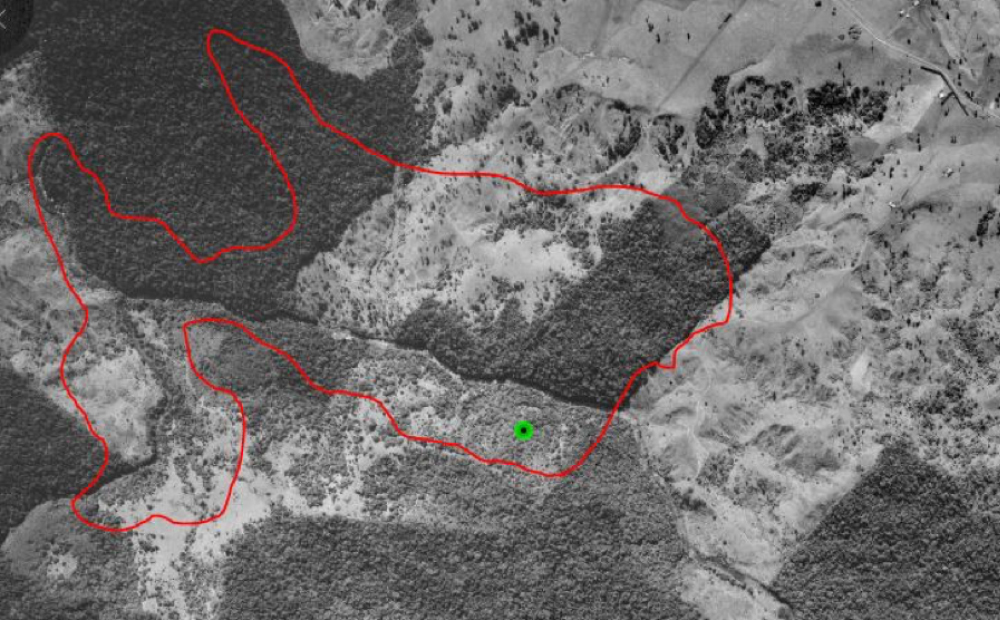
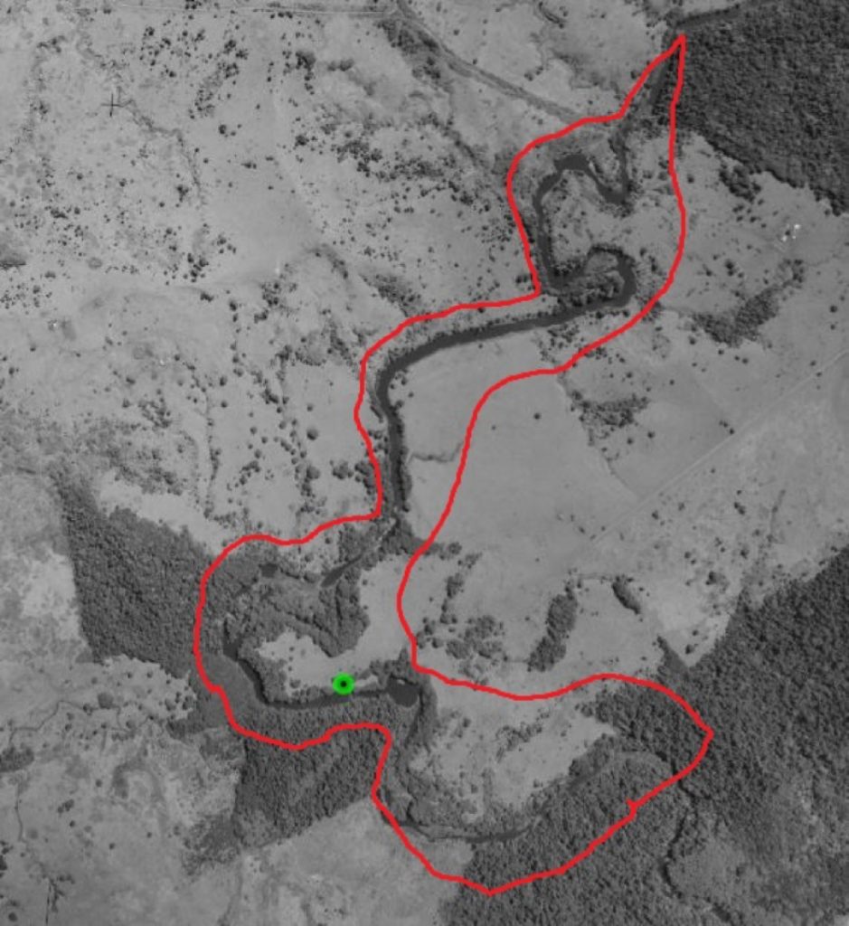
It has been estimated that 276ha of rainforest will be inundated. Only 13ha of original rainforest will be affected the rest being regrowth rainforest after these farms were found to be too steep and soil derived from Tully Granite too poor
to hold a pasture of commercial value.
Much of these regrowth rainforests are much depleted of original species and exhibit an overstorey of Acacias and Alphitonia. It is acknowledged that other species are reoccupying the site in the understorey, but it is far from original and could not be considered to be pristine.
These areas are however are marked as original rainforest under Queensland Vegetation Management so aerial photos have been included to prove this point (registered under Vegetation Management status RE 7.12.16 least concern
[no concern at present]).
The argument is that if a sacrifice to the environment has to be made then surely these areas of past degradation should be considered first.
There are no unique species within these sites that are not replicated in abundance within the Wooroonooran National Park downstream.
Birds and animals of these rainforest areas will be displaced by rising water. However the ponded areas will be relatively small and these critters are expected to move a short distance to existing rainforest at the site.
Cleared steep areas unsuitable for pasture maintenance and
a margin along the shoreline are expected to be re-vegetated to rainforest and this may well enhance the existing situation by providing native trees and pathways for native animals
to traverse.
Offsets for the project could be made through the purchase of rainforest properties on the Beatrice River.

Advantages and disadvantages
Economic, environmental and social advantages and disadvantages of North Johnstone water transfer proposal.
Economic
Advantages
- Expand agricultural potential in Mareeba-Dimbulah irrigation area.
- Secures Tinaroo Dam’s tourist and recreation potential.
- Boost for Tableland and coastal towns in development phase and some longer-term employment security for Tableland towns.
- Significant hydro electricity production potential from new dams.
- Barron Falls hydro capable of producing more power with increased flows downstream of Tinaroo Dam.
- Land to be inundated is steep, relatively poor country used for low density grazing.
- Less than 30km pipes required to connect to Tinaroo Dam.
- 380,000 megalitres per year minimum through these dams.
Disadvantages
- Land acquisition of several properties.
- Compensation required.
- Dams not effective in flood mitigation
(small and constantly at capacity). - Pipes needed to connect dams to
Tinaroo Dam.
Environmental
Advantages
- Catchment receives more than 2000mm annual rainfall.
- Dams are intended to capture 365km2.
- Rainfall is even over the whole catchment.
- Minimal environmental effect for maximum gain.
- Not within Wet Tropics World Heritage area.
- Clean power generation.
Disadvantages
- 276ha rainforest inundated.
Social
- Secure, long term water supply for Cairns.
- Water reticulation potential for Clohesy, Koah, Speewah and Myola – allowing for more residential settlement close to Cairns.
- No affect on downstream irrigators.
Disadvantages
- Temporary closure of several roads.
- Temporary discolouration of water.
- Three houses inundated.
- All rivers come under Native Title (Nadgunji).